Herføl island
Attractions, history, hiking suggestions
The Island of Cultural Treasures and Breathtaking Nature
Few places along the Oslofjord feel as exotic as Herføl, the southernmost inhabited island of Hvaler. Rarely has something so untouched been so beautiful as it is on Herføl—flirtatious in the summer sun, icy and bare in its winter coat, and rugged in the most captivating way.
Here, at the meeting point between the Outer Oslofjord and Skagerrak, nature draws visitors in with its dramatic landscapes, rugged and stunning pebble beaches, Norway’s largest burial mound, spectacular glacial potholes, and of course—the irresistible cinnamon buns at the café “På Posten.”

On Herføl, there is no car traffic—only the pleasant sounds of seagulls, a small boat softly going dunk-dunk, or teenagers revving an outboard motor while bottles clink in the background.
Herføl once had a customs station and a pilot service, and it was an important fishing hub.
Today, Herføl has evolved into a summer and tourist destination. Only 20 people live here year-round, while in the summer, visitors take over the island. However, it is not an island overrun by cabins—there are just around 150 holiday homes on Herføl.


About Herføl island
Herføl is one of the most exciting and distinctive islands in the Hvaler archipelago, known for its rocky coastal landscapes, rich cultural heritage, and deep roots in Norwegian history. This small yet significant island at the outer edge of the Oslofjord has been inhabited and utilized by humans for thousands of years, from Stone Age hunters to today's cabin owners and coastal enthusiasts.
The Stone Age and the First Settlers
Archaeological findings show that Herføl was inhabited as early as the Stone Age, around 8,000 years ago. The island's location at the entrance to the Oslofjord made it an important site for hunting and fishing, especially for the Stone Age people who relied on the sea for survival. Along the island's coast, flint tools and traces of early settlements have been discovered.
The Bronze and Iron Ages – Burial Mounds and Seafaring
Herføl also has many burial mounds from the Bronze and Iron Ages, suggesting that the island played an important role in trade and seafaring in prehistoric times. These burial mounds, which can still be seen today, are large piles of stones built by people to honor their dead. They were strategically placed on elevated terrain, making them visible from the sea—perhaps as symbols of power and ownership.
The island served as a natural harbor and resting place for seafarers, and it is likely that Vikings and merchants sailed past or made short stops here on their way to major trading hubs in Norway, Sweden, and Denmark.
The Middle Ages – Fishing and Trade
During the Middle Ages, Herføl remained an important part of the coastal community in Hvaler. The island was a key player in the large-scale fishing industry of the Oslofjord, where fishermen set out in small boats to catch herring, cod, and other seafood. The Hvaler islands were also known for their pilot services, where experienced sailors helped larger ships navigate safely through the dangerous waters of the archipelago.
At this time, Hvaler was part of Borgarsyssel len, governed from Sarpsborg, and the islands played a crucial role in trade between Norway and the rest of Europe.
The 1800s and 1900s – From Agriculture to a Summer House Paradise
In more recent times, Herføl was characterized by agriculture and fishing, but like many of the Hvaler islands, living conditions became increasingly difficult. By the late 1800s, several families began leaving the island in search of better opportunities on the mainland.
During the 1900s, Herføl gradually transformed into a summer paradise, where people from cities, especially Oslo and Fredrikstad, built cabins and used the island as a place for relaxation and recreation.
Today, very few people live on the island year-round, but during the summer months, it comes alive with cabin owners, hikers, and boaters who visit to experience the wild nature, breathtaking coastal cliffs, and the authentic maritime atmosphere.

Herføl Today – A Gem in Ytre Hvaler National Park
Today, Herføl is part of Ytre Hvaler National Park, which was established in 2009 to protect the unique archipelago nature and marine life in the area. The island is known for its diverse flora and fauna, stunning coastal landscapes, and rich cultural history.
Many visitors come to Herføl to:
🏝 Explore the ancient burial mounds and cultural heritage sites.
⛵ Go kayaking or take a boat trip around the archipelago.
🌿 Hike to Svanetangen, one of Norway's most spectacular glacial pothole areas.
🌊 Swim and sunbathe on the smooth coastal rocks and small beaches.

Look around
Attractions - Hiking Suggestions - Geography - Nature - Swimming Spots
What you see on a day trip
For those of us who enjoy hiking along the coast, Herføl is a true gem—all year round! Apart from a few scattered cabins, which are far from intrusive, you can embark on a peaceful, hours-long trek through unspoiled nature.
With smooth, polished coastal rocks, hidden coves, pebble beaches, Norway’s largest burial mounds, the country’s most impressive collection of glacial potholes, and a heather-covered landscape reminiscent of the Norwegian highlands, Herføl offers a diverse and breathtaking experience.
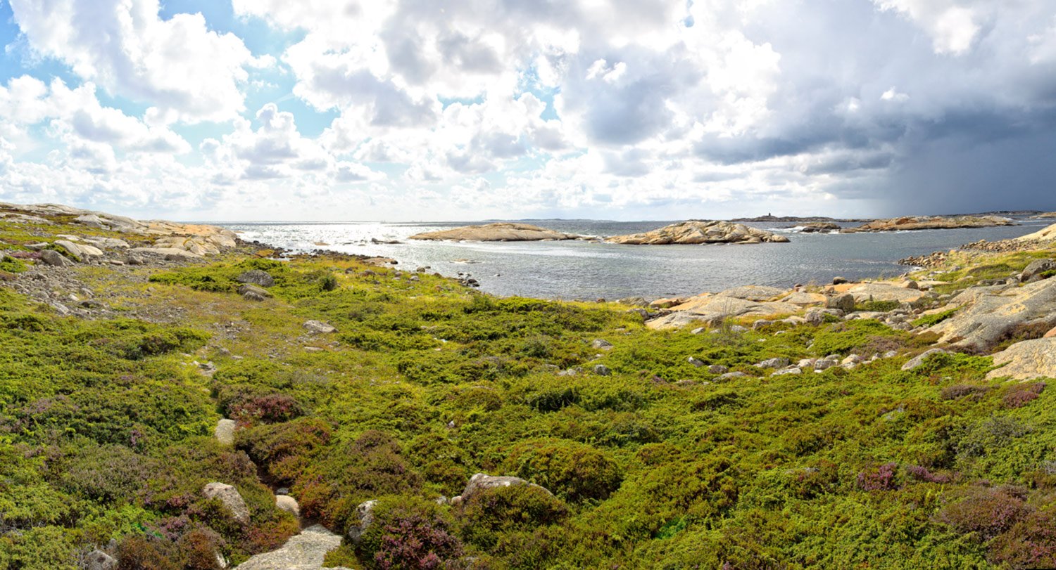
Herføl is an exceptionally beautiful island, and its landscape can be divided into two distinct natural areas.
You can draw a line from the northernmost point to the southern tip of Herføl, and you will see that the island is divided into two distinct natural and landscape areas—the calm and lush east, and the rugged, wild, and open terrain in the west.
The eastern part of Herføl lies sheltered by the ridge that runs through the island, protecting it from the strong ocean winds that hit the western side.
The eastern side of the island features a tranquil archipelago landscape, with forests, beaches, and beautiful views of Herfølrenna, the strait that separates Herføl and Søndre Sandøy. Most of Herføl's buildings and settlements are located on this side of the island.

The breathtaking view of the open sea greets you immediately as you step onto the western side of the island. Here, the landscape is completely exposed to the ocean, creating a rugged and windswept coastline. This part of Herføl is known for its harsh weather conditions, where the elements shape the raw beauty of the terrain.
To fully enjoy the vast stretches of smooth, polished coastal rocks, a strong wind is preferable—and on Herføl’s west side, wind is rarely in short supply. All year round, hiking in this majestic natural landscape is an incredible experience—especially in strong
southern or western winds (but be cautious where you step, particularly in snow-covered terrain).
On beautiful summer days, it’s a true pleasure to soak up the sun from the many rock ledges in the southwest, which serve as natural amphitheater seats with the ocean as the stage.
These rock formations are also excellent for swimming or as a stable platform for eager anglers casting their lines into the sea.

The island's network of trails is remarkably well marked. In open landscapes, such as rocky coastal areas and vast heathlands, there are no signs pointing the way, but you will find occasional painted markers on stones to guide you.
And if you venture off the trails, you’ll likely find your way easily thanks to the open terrain. Besides, straying from the beaten path only adds a little extra adventure and excitement to your hike!


The Country’s Largest Burial Mounds
"Herfølsåta" is a large Bronze Age burial mound that can be seen far out at sea. As expected for such a significant site, the mound is located in a commanding position with panoramic views in all directions.
Herføl is known as the saga island of Hvaler and Østfold. Its Old Norse name, "Herfyili," means "gathering place for the army."
Even in the Bronze Age and the Viking era, the island was a central location, as evidenced by the numerous Bronze Age burial mounds scattered across the landscape. "Herfølsåta" (known locally as "Røsset") is one of Norway’s largest burial mounds, measuring nearly 30 meters in diameter. This is one of Norway’s most remarkable burial sites, majestically perched near the second-highest point on Herføl. It stands as a powerful testament to the beliefs and traditions of the people who lived here thousands of years ago.
Photo above by Carina Husom

Image above: Herfølsåta. After about a 10-minute walk up from the ferry dock, you will find yourself at the burial mound "Herfølsåta". This is Østfold’s largest Bronze Age burial mound. It is listed on the Norwegian Cultural Heritage Council’s list of high-priority national cultural monuments and has been designated as a "National Monument" (Riksmonument). Herfølsåta, also known locally as "Røsset," sits on one of the highest points on Herføl, offering a stunning panoramic view over the island.
A Rare Long Cairn at the Southern Tip of the Island
At the southern end of the island, you’ll find a rare long cairn, approximately 100 meters long, known as "Langrøset". The burial chamber is clearly visible as you carefully balance your way across the rolling stones.
"Langrøset" is the longest of its kind in Norway. Both "Herfølsåta" and "Langrøset" tell the story of the region’s fascinating Bronze Age history and stand as impressive monuments that are well over 3,000 years old.


“
Do you believe that the past truly exists?”

Beautiful nature, spectacular glacial potholes, and the maritime landmark of the border sea.
Another landmark visible from far out at sea is Linnekleppen, standing 32 meters high with an imposing cairn that measures nearly 9 meters in height. This cairn is said to be one of the most dominant in the archipelago.
Linnekleppen, which is Herføl’s highest point, is located in the southwest of the island. A hike up to the cairn rewards you with a breathtaking view of the Skagerrak horizon and Sweden, including the Koster Islands.
Image above: It is easy to understand why many sailors use the Linnekleppen cairn as a navigation marker when approaching the Hvaler archipelago.
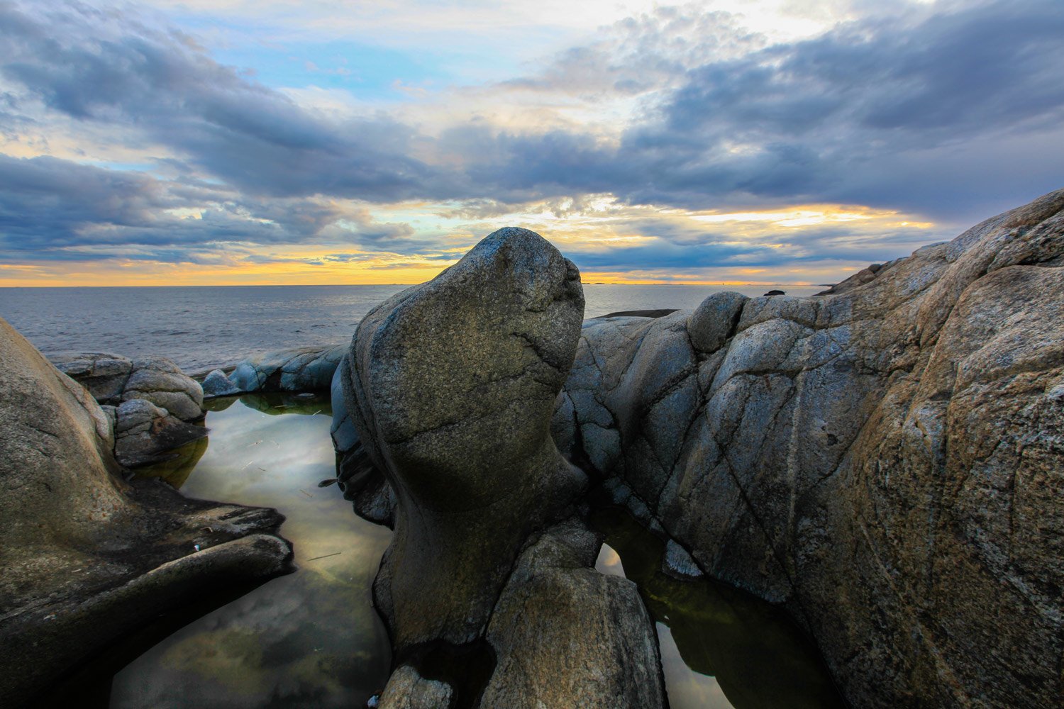
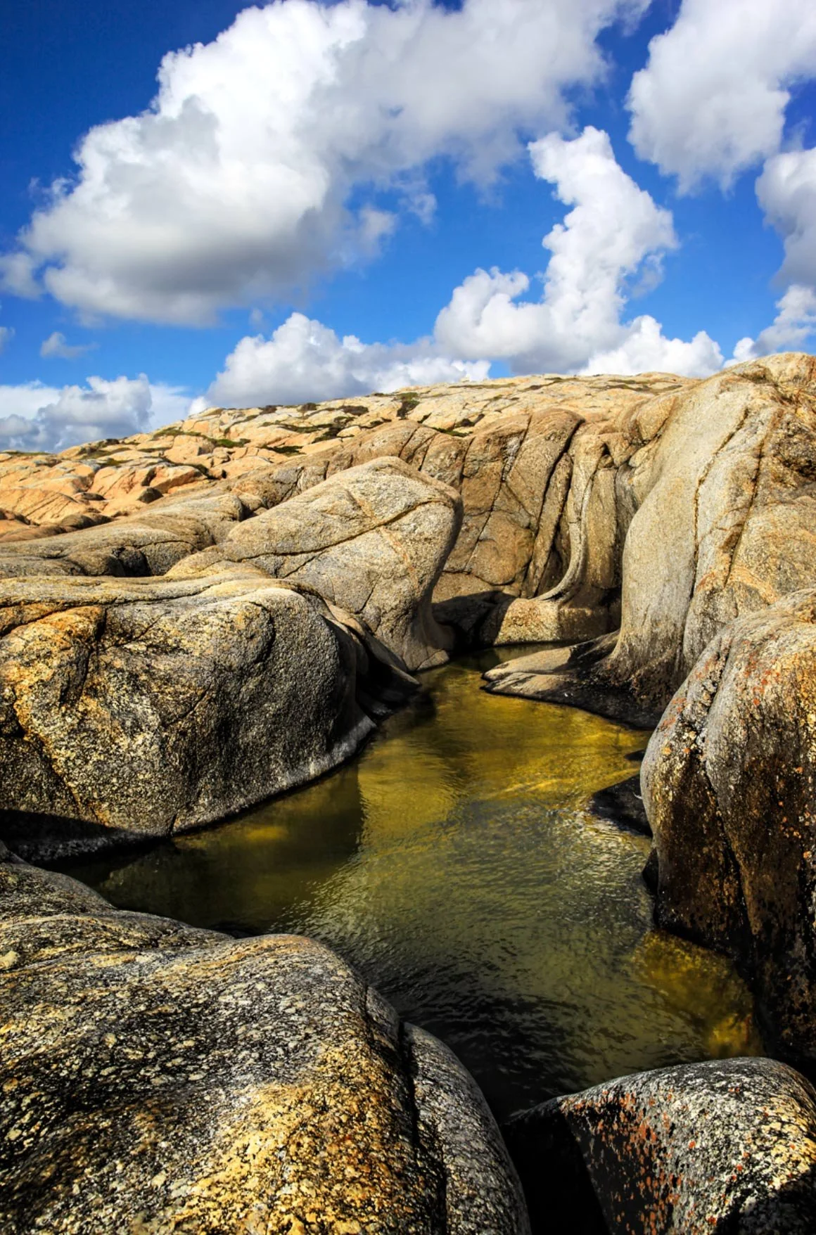
Glacial Potholes on Herføl – A Geological Treasure
On the island of Herføl in the Hvaler archipelago, several glacial potholes can be seen on the smooth coastal rocks. Here, you can witness how the forces of the sea continue to shape the landscape, and some of the potholes fill with water, creating small natural pools.

From Linnekleppen, you can continue your hike southward across the coastal rocks toward "Katedralen", the large glacial pothole shaped like a Gothic church window. At "Katedralen," you'll find a stunning landscape of smooth coastal rocks. Take a moment to enjoy the incredible rock formations sculpted by the Ice Age.

The Ocean’s Cathedral. Along the western side of the island and at the southernmost part of Herføl, you’ll find many fascinating glacial potholes. Some are large enough to sit in, while others can be used as small natural pools for bathing. In the image, you can see the glacial pothole "Katedralen" (The Cathedral).
“For the history and the landscape, or rather, the landscape and the history, are inseparably connected.”


Photo by Hege Cecilie Melfald Bergh - hcmb71
“A time will come when those who remembered me are forgotten.”
Glacial Potholes – Nature’s Own Sculpture
Glacial potholes are one of nature’s most fascinating formations—round, deep holes in the bedrock, shaped over thousands of years by the relentless power of water. These geological wonders can be found in many places across Norway, especially along the coastline and in rivers, each one telling a story of nature’s slow yet unstoppable ability to shape the landscape.
How Are Glacial Potholes Formed?
Glacial potholes form when meltwater from glaciers sets stones in motion, causing them to swirl in a vortex-like movement over a long period of time. The stones, along with sand and gravel, gradually grind down the bedrock, carving out cylindrical depressions in the stone.
Imagine a giant natural drill, where swirling water, sand, and stones have gradually carved out perfectly smooth, circular basins in solid rock. Some are small enough to fit your hand, while others are big enough to sit in—or even swim in! They’re like ancient fingerprints of time, silent reminders of the forces that have shaped our world.
This often happens:
🌊 In waterfalls and rivers, where the force of the water creates a swirling motion in the stones.
❄ Under glaciers, where meltwater carves its way into the bedrock.
⛵ Along the coast, where tidal movements contribute to further shaping the potholes.
Over tens of thousands of years, glacial potholes can become large enough to fit a person or even serve as small natural pools!
Image: The Scream Along the Coast. Photo by Glenn Meling - @glennmeling - www.glennmeling.com

What Can You Do at Glacial Potholes?
🔍 Explore and learn more about geology.
📸 Take spectacular photos of these natural formations.
🌊 Swim in the largest glacial potholes (where it is safe!).
🚶♂️ Go on a nature adventure and observe how water has shaped the landscape.
A Natural Time Machine
Glacial potholes are living proof of the Ice Age’s power, offering us a unique opportunity to understand how the landscape has been shaped over millions of years. Whether you visit the coast, mountains, or inland areas, you can find these fascinating natural formations—and reflect on the thousands of years it took for them to form.
🌍✨ Next time you see a glacial pothole, remember that you are standing by a natural masterpiece—created by water and stone over countless years! ⏳🪨
Where Can You Find Glacial Potholes in Norway?
Norway is home to many impressive glacial potholes, including:
Nissedal (Telemark County) – One of Norway’s largest collections of glacial potholes.
Helvete (Innlandet County) – Some of the largest glacial potholes in Northern Europe.
Åkrafjorden (Vestland County) – Spectacular glacial potholes carved into steep mountainsides.
Hvaler Archipelago (Østfold County) – Several small and large glacial potholes along the coastline.


Svanetangen – A Unique Natural Area Known for Its Impressive Glacial Potholes
Svanetangen offers a spectacular geological experience, where the forces of nature have shaped some of the most fascinating formations along the coast over thousands of years.
🌊 Located on the southwestern side of Herføl, Svanetangen is where smooth coastal rocks meet the sea, creating a dramatic coastline. Here, you will find a large number of glacial potholes, ranging in size from small depressions to large, natural pools. Some are deep and round, while others have twisted, irregular shapes—all a result of the powerful forces of the Ice Age.
Svanetangen on Herføl is a place where you can truly sense the passage of time and nature’s incredible creative power. The area offers a unique combination of geology, history, and coastal beauty, making it an unforgettable experience.
✨ Visit Herføl and discover the mysterious glacial potholes of Svanetangen—one of Hvaler’s most stunning natural wonders! 🌊🪨

Practical Information for Visiting Svanetangen
📍 Beliggenhet: Svanetangen, sørvest på Herføl, Hvaler
⛴ How to Get There:
Take the ferry from Skjærhalden to Herføl.
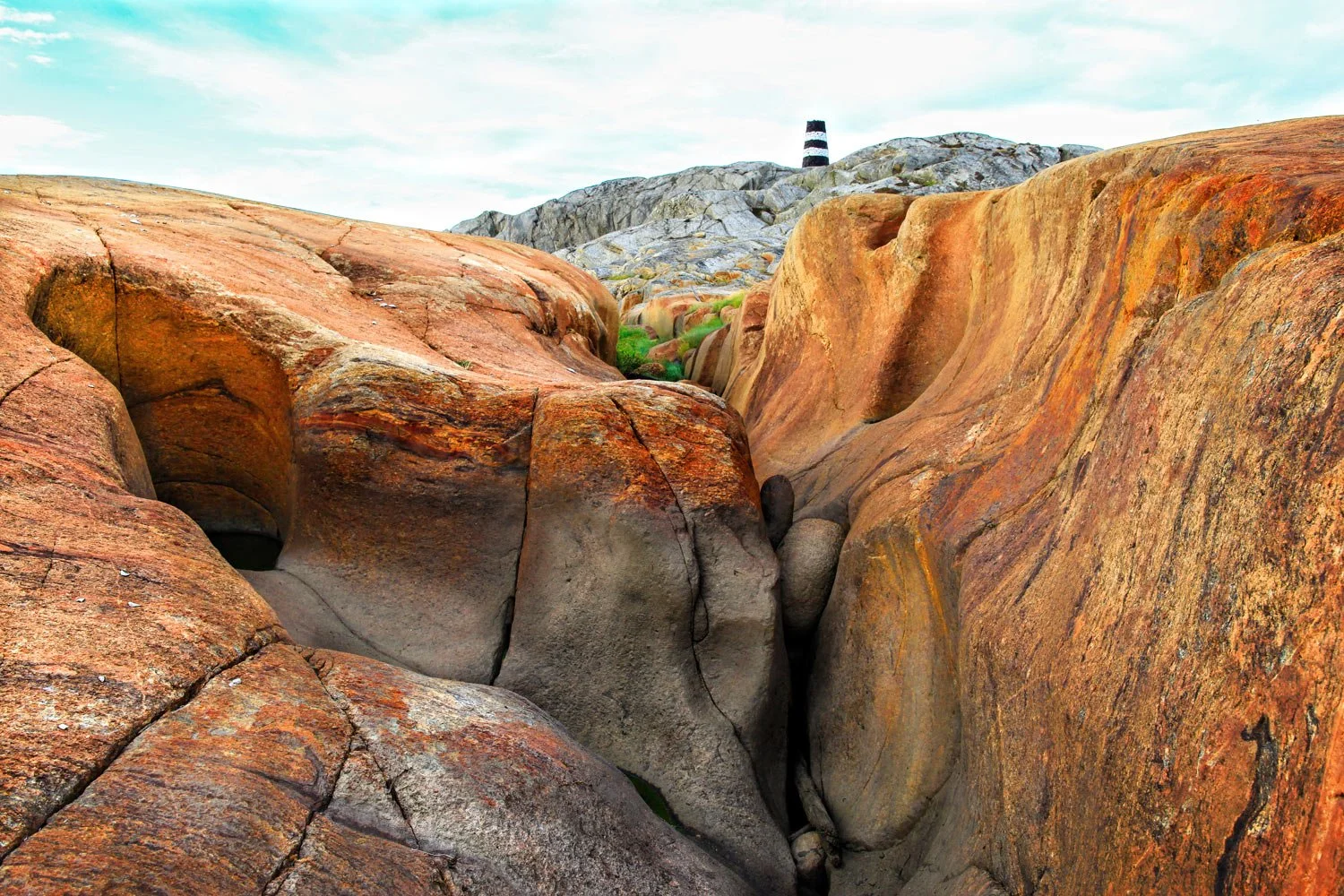
Walk or bike from the ferry dock to Svanetangen (approx. 20–30 minutes). The image here shows the final part of the hike before reaching Svanetangen. You simply need to walk up the ridge visible in the picture, and you’ll arrive at Svanetangen.
Travel by private boat or kayak to explore the area from the sea.
🎒 Hiking Tips:
Wear sturdy shoes—the coastal rocks can be slippery.
Bring swimwear if you want to take a dip in a glacial pothole.
Enjoy a picnic with a stunning ocean view.
What Can You Experience at Svanetangen?
🪨 Explore the glacial potholes – Walk along the coastal rocks and see how the natural pools are scattered across the landscape.
📸 Take spectacular photos – The light, the rock formations, and the sea create an incredibly beautiful backdrop.
🐚 Observe marine life – Some potholes fill with seawater and function as small tidal pools, where you can find seaweed, small fish, and shells.
🌊 Swim in the potholes – Some of the larger ones are deep enough for a refreshing dip on warm summer days.
🚶♂️ Hike and enjoy the nature – The area offers a fantastic view of the Skagerrak and the Hvaler archipelago.

“Time is with us.”
“What is, is what has been.”

Read part 2 about Herføl
Beaches, flora, map, transport options, Andholmen, and Henry A. Larsen
Photo by Carina Husom